The India-Tibet Boundary becomes the Sino-Indian boundary
- Atlas of the Northern Frontier of India (Part 1)
Published by the Ministry of External Affairs (1960)
- The India-Tibet (China) Boundary
The Chinese Aggression in maps (1963)
Map 1
- The India-Tibet (China) Boundary
The Chinese Aggression in maps (1963)
The line separating Indian and Chinese Forces on 7 September 1962 in Western Sector
Maps 2
- The India-Tibet (China) Boundary
Chinese Aggression in Maps (1963)
Chinese Claim Lines of 1956 and 1960 in Western Sector
Map 3
- The India-Tibet (China) Boundary
Chinese Aggression in Maps (1963)
Roads Constructed and Posts set up Illegally by Chinese Since November 1959 in Western Sector
Map 4
- The India-Tibet (China) Boundary
Chinese Aggression in Maps (1963)
Line of Actual Control in November 1959 and September 1962 in Western Sector
Map 5
- The India- Tibet (China) Boundary
Chinese Aggression in Maps (1963)
Chinese Advances before 8 September 1962 and after 8 September 1962 in Western Sector, and the Area which they are prepared to Demilitarise
Map 6
- The India-Tibet (China) Boundary
Chinese Aggression in Maps (1963)
Extent of Indian Territory and Indian Posts to be evacuated by Indian Forces in Western and Middle sectors under China’s Three-Point Proposal
Map 7
- The India-Tibet (China) Boundary
Chinese Aggression in Maps (1963)
Line separating Indian and Chinese Forces on 7 September 1962 in Eastern Sector
Map 8
- The India-Tibet (China) Boundary
Chinese Aggression in Maps (1963)
The McMahon Line
Map 9
- The India-Tibet (China) Boundary
Chinese Aggression in Maps
Extent of Indian Territory and Indian posts to be Evacuated by Indian Forces in Eastern Sector under China’s Three-point proposal
Map 10
- Ladakh and the Aksai Chin
Evolution of the border in Ladakh between 1958 and 1962
- The Indo-Tibet Boundary
The Central Sector of the Indo-Tibet boundary with the passes notified in the Panchsheel Agreement
- The Aksai Chin road
Map of the Aksai Chin road cutting across Eastern Ladakh
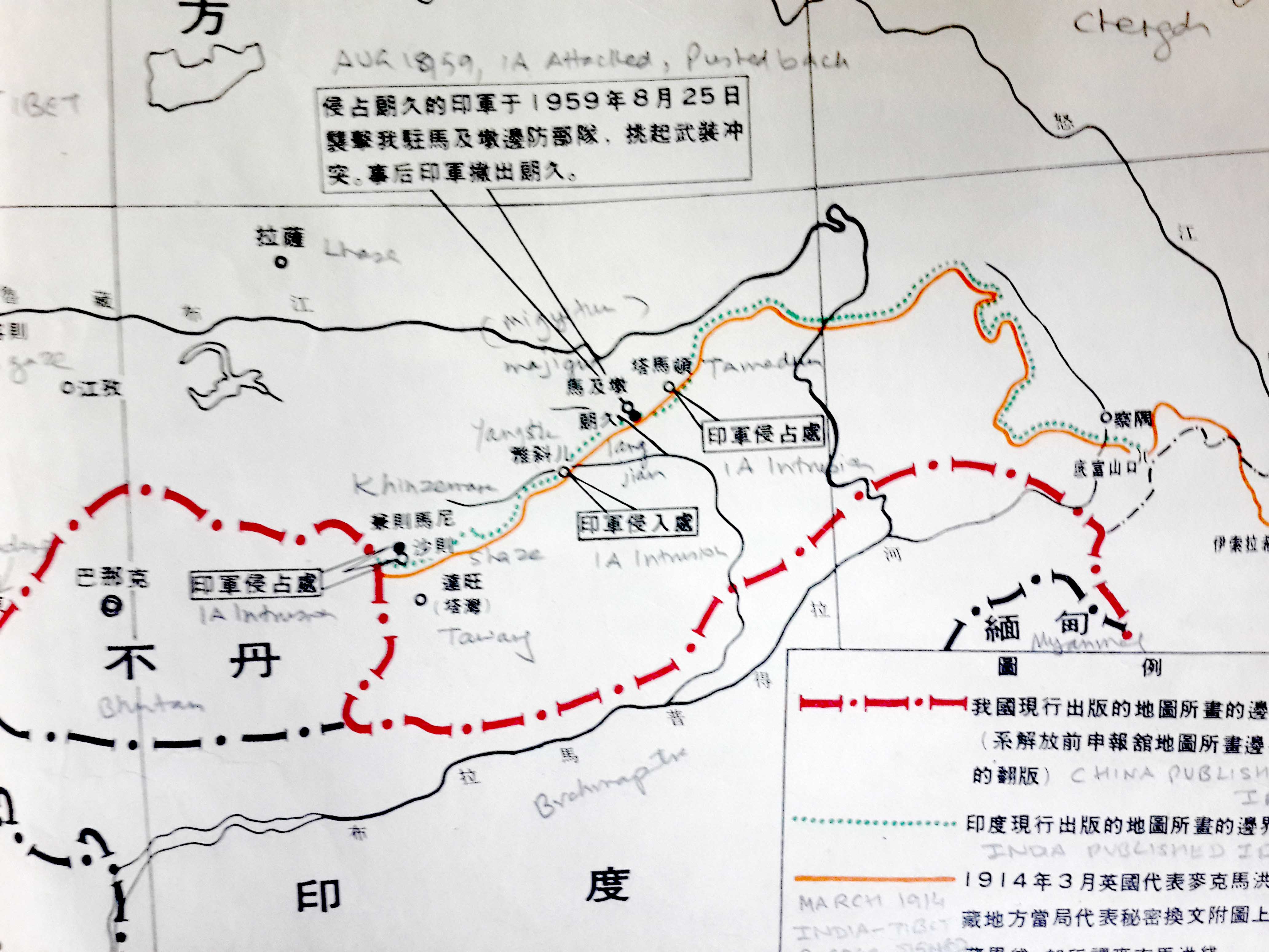
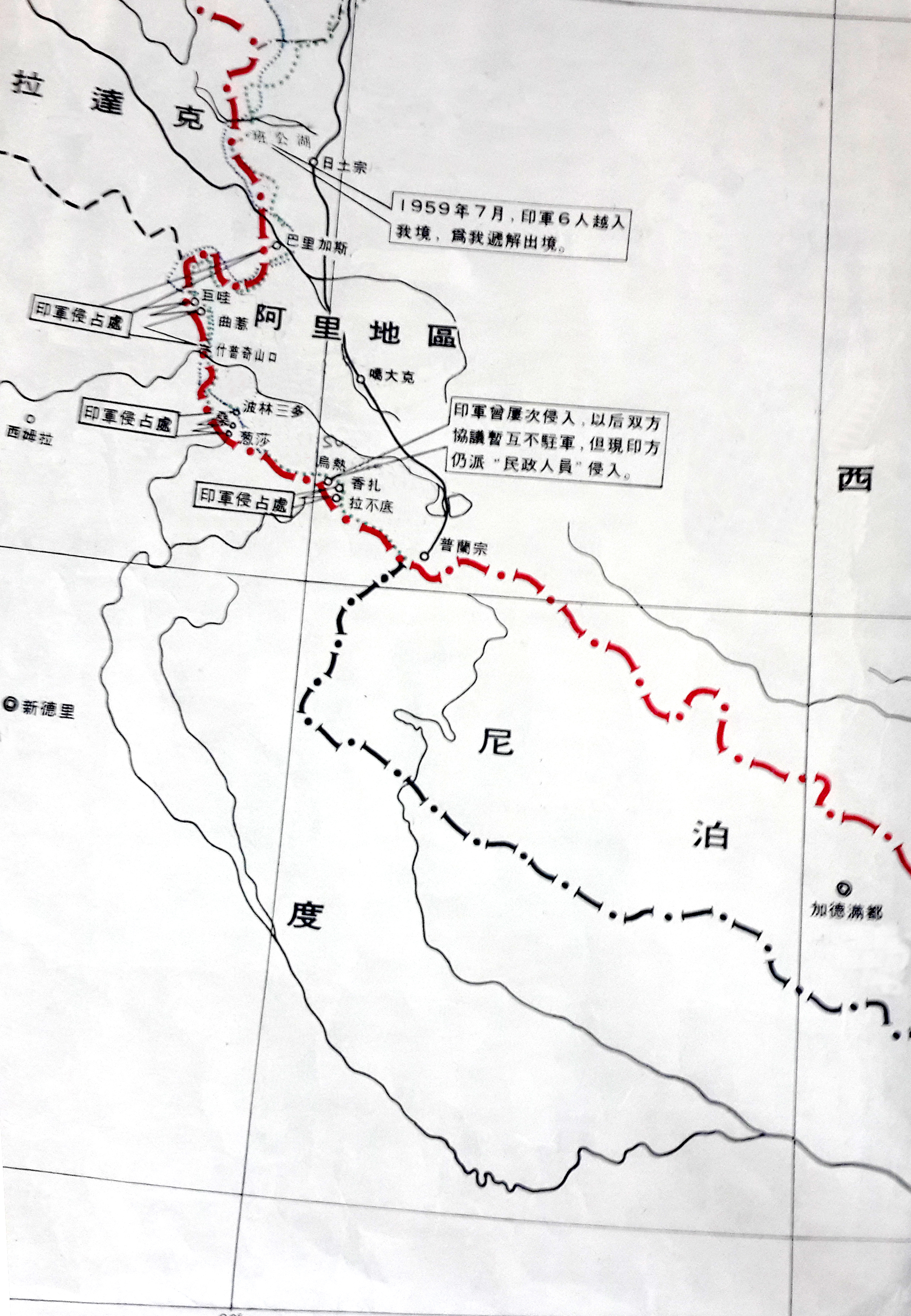
Maps of the Chinese claims on India’s territory
- The Chinese claims in Ladakh
1959 – The Chinese claims in the Ladakh Sector and the presumed Indian transgressions (as seen by China)
- The Chinese claims in NEFA/Arunachal Pradesh
1959 – The Chinese claims in the NEFA Sector and the presumed Indian transgressions (as seen by China)
- The Chinese claims in the Central Sector
1959 – The Chinese claims in the Central Sector and the presumed Indian transgressions (as seen by China)
The 1962 Sino-Indian War
- Map of the 1962 operations in the Namkha chu area
Map by Brig John Dalvi, Commander of 7 Brigade
- Operations in Western Sector in 1962
Sketch showing the first phase of the operations in the Western Sector during the 1962 War (October 20-28, 1962)
- The McMahon Line
Details of the line near the Thagla ridge and Namkha chu
My Maps
- Map of the Tsari Pilgrimage
Map of the Tsari pilgrimage in Tibet and Arunachal Pradesh
- Map Walong and Lohit Sector
Map of Walong in Lohit Valley and Choglagam (Arunachal Pradesh)
- Map of Tawang Sector
Map of the Valley of the Tawang area (Arunachal Pradesh)
- Map of Siang Sector
Map of the Valley of the Siang (Arunachal Pradesh)
- Map of Subansiri Sector
Map of the Valley of the Subansiri (Arunachal Pradesh)
- Map of the Tribes of Arunachal Pradesh
Map of the different tribes in Arunachal Pradesh
- Map of Barahoti and Lapthal
The map shows the Chinese claims in this area located in today’s Chamoli district of Uttarakhand
Other maps
- Eastern Himalaya
1940 – Map prepared by Frank Ludlow during his visit to NEFA
- Northeastern Frontier And Tibet
1913- Map prepared by Capts Morshead and Bailey for the 1914 Simla Convention
- Monyul by Morshead and Bailey
1913 – details of the previous map
- Map of Tibet and United Province
1910 – Map of Garhwal District (Tehri State) with Tibet with comments by Percy Wyndham
- Route of Younghusband in Tibet
1904 – Map of the route taken by Capt Francis Younghusband during his expedition in Tibet
- British Expedition To Lhasa
1904 – Map of the Younghusband Expedition to Tibet
- Kumaon And Tibet
1900 -Map of Kumaon by Strachey
- Tibet Sikkim And Bhutan
1888 – Map showing Explorer Routes by the Survey of India
- Hydrography of South Eastern Tibet
1888 – The Hydrography of Tibet
- The Tsangpo Controversy
1885 – The Tsangpo-Irrawadi Controversy
- Route of Kishen Singh in Western Tibet
1874 – The route of the Pandit Kishen Singh in Western Tibet
- Ngari Khorsum and Ladakh
1851 – map of Strachey of Western Tibet and Ladakh
- Ladakh with parts of Balti and Monyul
1851 – map of Strachey of Balti and Monyul
- Kumaon and British Garhwal
1850 – A map of Kumaon and Garhwal
- The Tsari Rongkor
Routes of the Small and Long Tsari Pilgrimages
- Map of Minsar
Map of the Indian principality of Minsar near the Kailash
Maps prepared by Hugh Richardson
- Map of the Tibetan Précis
Richardson was the British (and India) Representative in Tibet
The map of a dispute in NEFA - Map of The Tibetan Précis
Richardson was the British (and India) Representative in Tibet
The map of a dispute in Ladakh
- Map of The Tibetan Précis
Richardson was the British (and India) Representative in Tibet
The map of Nilang/Jadhang area
The McMahon line
- The McMahon Line and the Aksai Chin
1914 – The western end of the McMahon Line corresponds with the Indian claim in the Aksai Chin area
- The McMahon Line
The McMahon Line signed by Tibetan and British Plenipotentiaries
Map 1
- The McMahon Line
The McMahon Line signed by Tibetan and British Plenipotentiaries
Map 2
US Joint Operations maps
- Map of the Aksai Chin (Ladakh)
Map of the Aksai Chin area (Map of NI-44-1)
US Joint Operations Graphic 1:250,000 U.S. National Imagery and Mapping Agency
- Map of Chushul Dumchele (Ladakh)
Map of Chushul and Dumchele (NI-44-9)
US Joint Operations Graphic 1:250,000 U.S. National Imagery and Mapping Agency
- Map of Tso Moriri
Map of Tso Moriri (NI-44-13)
US Joint Operations Graphic 1:250,000 U.S. National Imagery and Mapping Agency
- Map of the Aksai Chin
Map of Aksai Chin area (NI-44-14)
US Joint Operations Graphic 1:250,000 U.S. National Imagery and Mapping AgencyI-44-14