Atlas of the Northern Frontiers of India
Atlas of the Northern Frontiers of India
by Ministry External Affairs
Part 1
1960
Atlas of the Northern Frontiers of India
by Ministry External Affairs
Part 2
1960
Atlas of the Northern Frontiers of India
by Ministry External Affairs
Part 3
1960
Atlas of the Northern Frontiers of India
by Ministry External Affairs
Part 4
1960
Atlas of the Northern Frontiers of India
by Ministry External Affairs
Part 5
1960
Maps prepared by Hugh Richardson
Map of the Tibetan Précis
Richardson was the British (and India) Representative in Tibet
The map of a dispute in NEFA
Map of The Tibetan Précis
Richardson was the British (and India) Representative in Tibet
The map of a dispute in Ladakh
Map of The Tibetan Précis
Richardson was the British (and India) Representative in Tibet
The map of Nilang/Jadhang area
The India-Tibet boundary becomes the Sino-Indian boundary
The India-Tibet (China) Boundary
The Chinese Aggression in maps (1963)
Map 1
The India-Tibet (China) Boundary
The Chinese Aggression in maps (1963)
The line separating Indian and Chinese Forces on 7 September 1962 in Western Sector
Maps 2
The India-Tibet (China) Boundary
Chinese Aggression in Maps (1963)
Chinese Claim Lines of 1956 and 1960 in Western Sector
Map 3
The India-Tibet (China) Boundary
Chinese Aggression in Maps (1963)
Roads Constructed and Posts set up Illegally by Chinese Since November 1959 in Western Sector
Map 4
The India-Tibet (China) Boundary
Chinese Aggression in Maps (1963)
Line of Actual Control in November 1959 and September 1962 in Western Sector
Map 5
The India- Tibet (China) Boundary
Chinese Aggression in Maps (1963)
Chinese Advances before 8 September 1962 and after 8 September 1962 in Western Sector, and the Area which they are prepared to Demilitarise
Map 6
The India-Tibet (China) Boundary
Chinese Aggression in Maps (1963)
Extent of Indian Territory and Indian Posts to be evacuated by Indian Forces in Western and Middle sectors under China’s Three-Point Proposal
Map 7
The India-Tibet (China) Boundary
Chinese Aggression in Maps (1963)
Line separating Indian and Chinese Forces on 7 September 1962 in Eastern Sector
Map 8
The India-Tibet (China) Boundary
Chinese Aggression in Maps (1963)
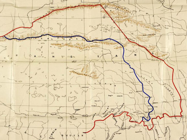
The McMahon Line
Map 9
The India-Tibet (China) Boundary
Chinese Aggression in Maps
Extent of Indian Territory and Indian posts to be Evacuated by Indian Forces in Eastern Sector under China’s Three-point proposal
Map 10
Ladakh and the Aksai Chin
Evolution of the border in Ladakh between 1958 and 1962
Maps of the Chinese claims on India’s territory
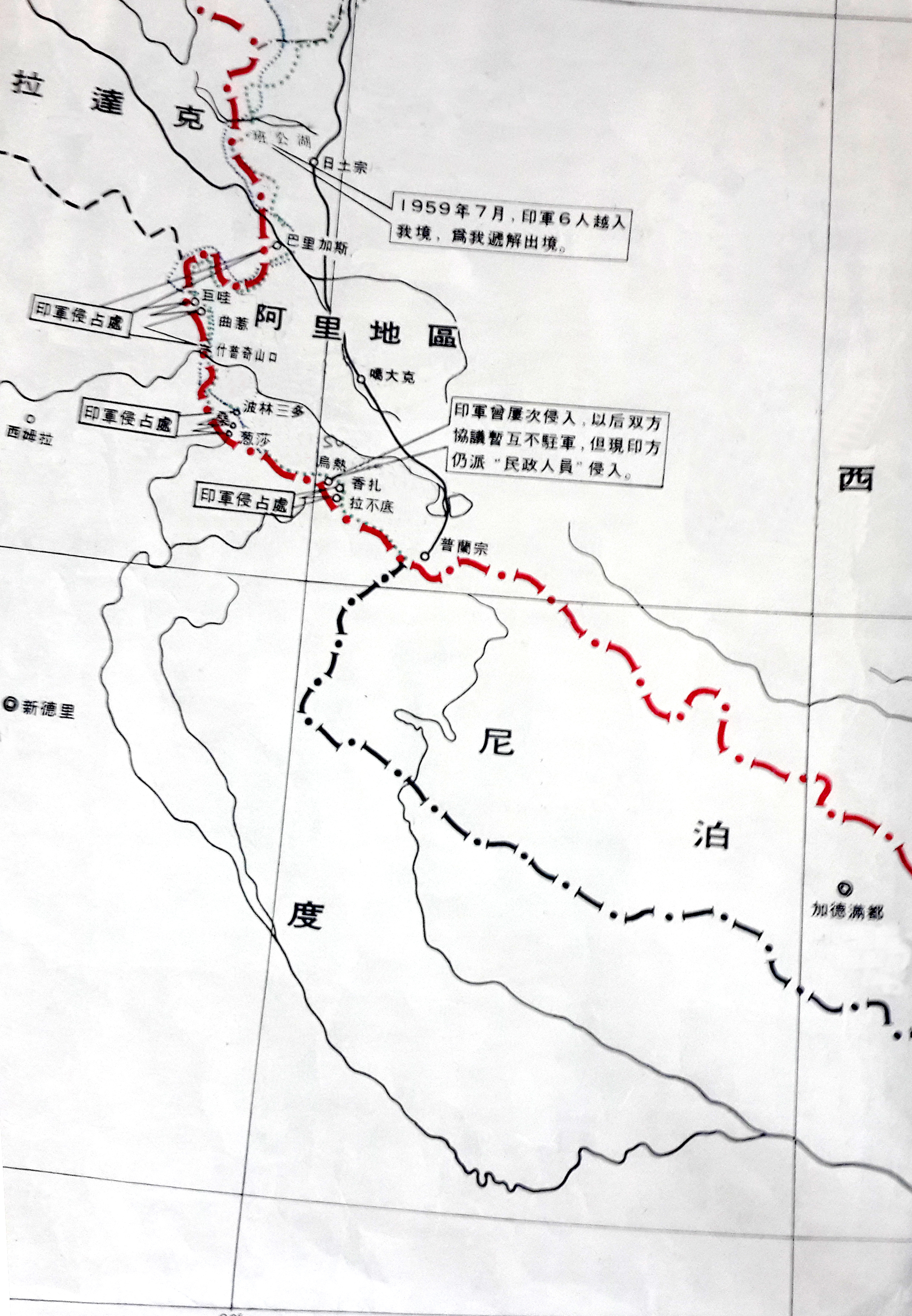
The Chinese claims in Ladakh
1959 – The Chinese claims in the Ladakh Sector and the presumed Indian transgressions (as seen by China)
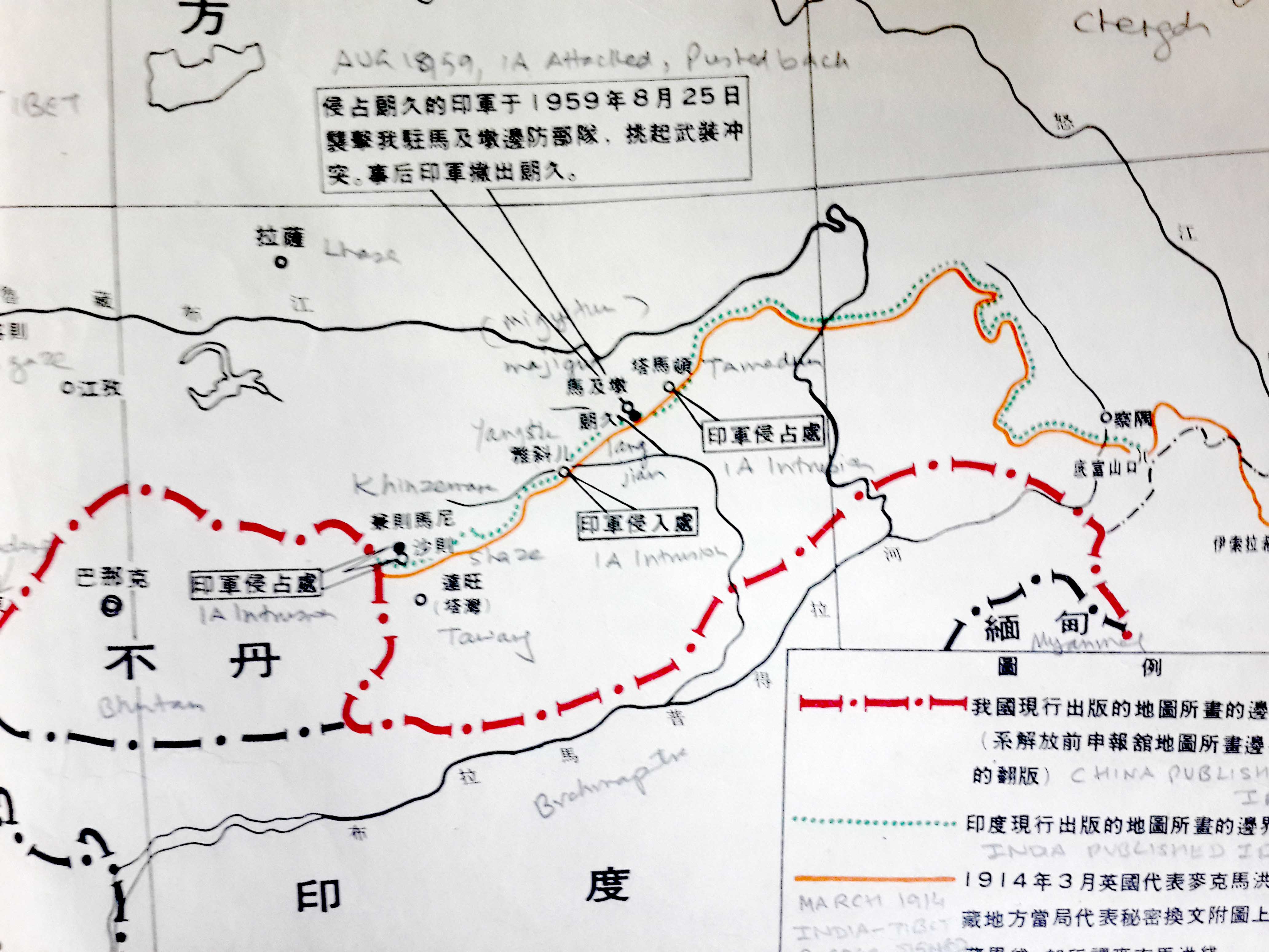
The Chinese claims in NEFA/Arunachal Pradesh
1959 – The Chinese claims in the NEFA Sector and the presumed Indian transgressions (as seen by China)
The Chinese claims in the Central Sector
1959 – The Chinese claims in the Central Sector and the presumed Indian transgressions (as seen by China)
The 1962 Sino-Indian War
Map of the 1962 operations in the Namkha chu area
Map by Brig John Dalvi, Commander of 7 Brigade
Operations in Western Sector in 1962
Sketch showing the first phase of the operations in the Western Sector during the 1962 War (October 20-28, 1962)
The McMahon Line
Details of the line near the Thagla ridge and Namkha chu