
Survey of India pre-Independence maps (from the Library of Congress)
Kaurik Sector
Ref: 52 L
Source: Survey of India
1945
Chini Sector
Ref: 53 L
Source: Survey of India
1945
Kangra District and United Provinces
Ref: 53 I
1945
53 J Dehra Dun (1947)
Ref: 53 J
Source: Survey of India
1947
Bijnor
Ref: 53 K
1966
Tibet and United Provinces
with comments by Percy Wyndham
Ref: 53 M
Source: Survey of India
1923
Badrinath
Ref: 53 N
Source: Survey of India
1945
Naini Tal
Ref: 53 O
Source: Survey of India
1946
Almora
Ref: 62 B SW
Source: Survey of India
1944
Manasarowar
Ref: 62 F
Source: Survey of India
1945
Simikot
Ref: 62 G
Source: Survey of India
1945
Lipu Lekh Pass with Kalapani
Ref: 62 B
Source: Survey of India
1879
Old Maps
Kumaon
by Webb
Source: pahar.in
1819
Geological Map of Sutluj to Kalee
by Herbert
Source: Survey of India
1826
Map of Route to Rakas Tal and Manasarovar
by H. Strachey
Source: pahar.in
1848
Kumaon and British Garhwal
by Strachey
Ref: F25-16
Source: pahar.in
1850
Kumaon and British Garhwal
Source: pahar.in
1850
Nari Khorsum
by Strachey
Source: pahar.in
1851
Map of West Nari and Indian Himalaya
by H. Strachey
Source: pahar.in
1854
Indus and Sutlej Rivers
by Montgomerie
Source: pahar.in/SoI
1867
Basins of Indus and Sutlej Rivers
by Montgomerie
Source: pahar.in
1868
Himalayan Valleys of Kooloo, Lahoul and Spiti
Source: pahar.in
1871
Route of Kishen Singh in Western Tibet
Source: pahar.in
1874
Kumaun and British Garhwal
Source: pahar.in
by GTS (No 36)
1878
from Shipki to Tirthapuri
Indian Atlas Sheet 65
Source: pahar.in
1900
Kumaon and Tibet
by H. Strachey
from RGS
Source: pahar.in
1900
Tibet and Sin-Chiang
by Deasy
Source: pahar.in
1900
Tibet and the Surrounding Regions
by RGS
Source: pahar.in
1906
Western Tibet
from CA Sherring
Source: pahar.in1906
Sven Hedin Tibet Explorations
Source: pahar.in
1909
Tibet with Hedins route
from Trans Himalaya
Source: pahar.in
1909
Tibet and Adjacent Countries
Source: pahar.in
1914
Surveys and Explorations in Himalayas and Central Asia
Source: pahar.in
1934
Spiti
by Tucci
from Secrets of Tibet
Source: pahar.in
1935
Other Maps
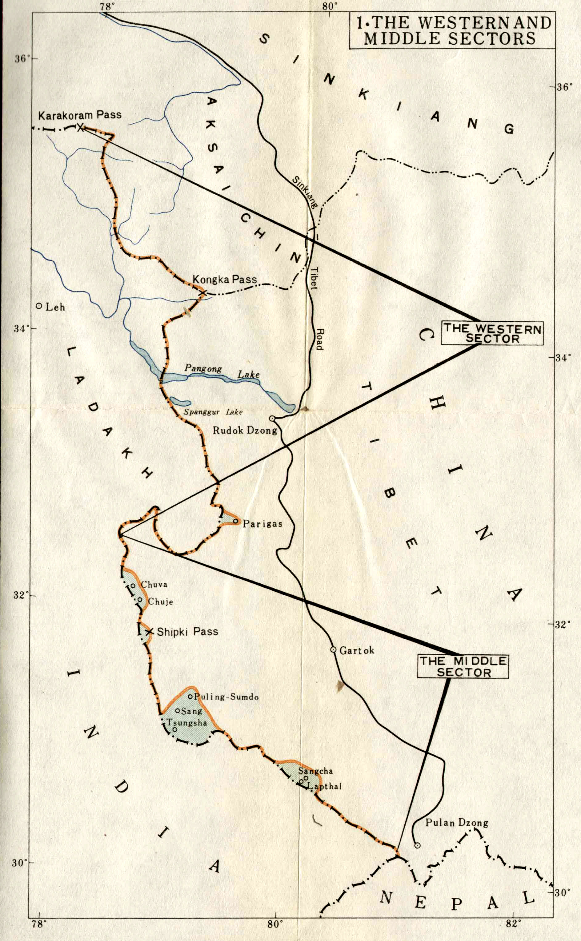
The Indo-Tibet Boundary
The Central Sector of the Indo-Tibet boundary with the passes notified in the Panchsheel Agreement
Source: Colombo Plan
1963
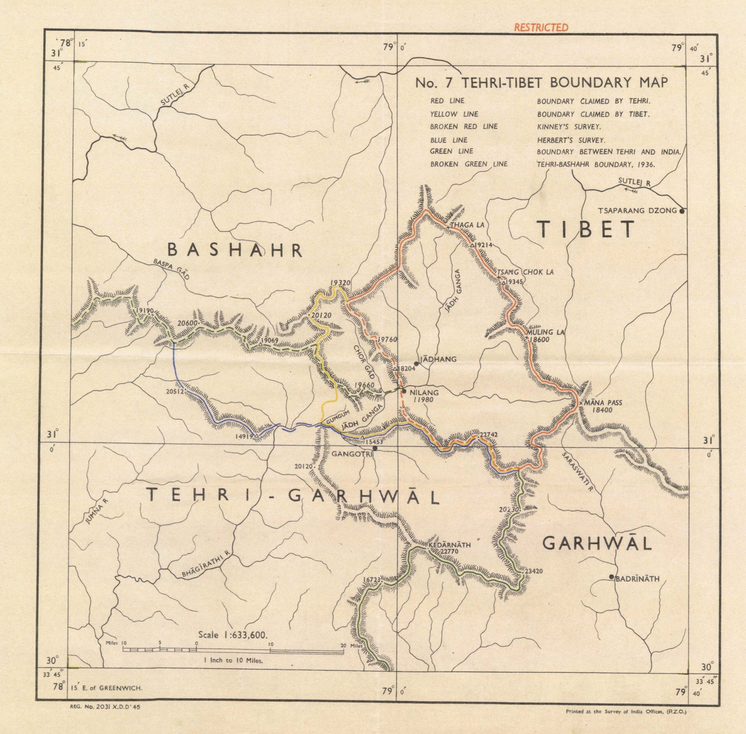
Tehri-Tibet Boundary
by HE Richardson
from Tibetan Precis
1945
Tibet
from Times Atlas
showing Nain Singh Range
Source: pahar.in
1958
Central & Eastern Sector
China’s claims
December 1962
Central-Sector
China’s claims
December 1959
Trijunction Lipulekh
from Nepal-China Border Agreement
1963
Nanda Devi
Ref: MH 44-6
Ref: US Military Maps
Central Tibet
China’s claims
Note date